Share & publish
Bring all your data en docs together, in one place.
[ Collect & Connect ]
Bring every source together in one place
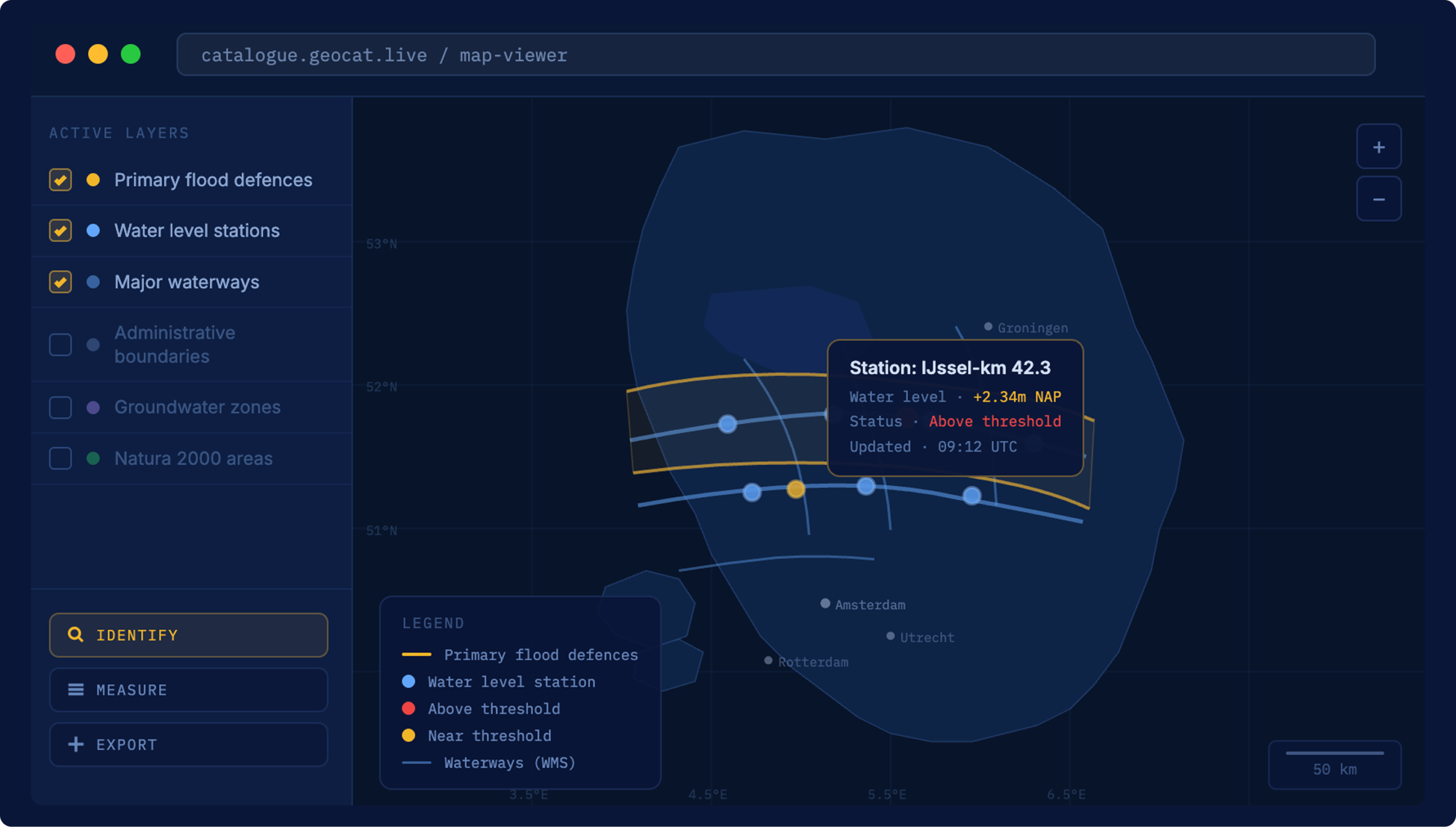
Your geodata rarely lives in one system. GeoCat connects to the places it already sits — spatial servers, file stores, databases, other catalogs and open data portals — and harvests their metadata into a single, structured catalog. Built on GeoNetwork opensource and open international standards, so nothing stays trapped in a silo.
[ Why start here ]
Everything begins with connected data
Plug into the sources you already use
Set up harvesters for CSW, OGC API, WMS/WFS, CKAN and more. GeoCat reaches out to each source on a schedule and pulls in what's new — no manual exports, no copy-paste.
Compliant metadata, automatically
As records arrive they're aligned to ISO 19115, OGC, INSPIRE and DCAT. View services and related metadata come out the other side ready to share.

One place for data and documents
Spatial layers, datasets and the documents that describe them land in a single catalog — searchable, de-duplicated and linked, instead of scattered across drives and portals.
Solid development and support
GeoCat handles development, security and up to 5 years of life-cycle support on the underlying GeoNetwork opensource platform, so your team can focus on the data.
[ Deployment ]
Run it your way — hosted, on-premise or hybrid
From scattered files to a unified, searchable catalog, on the infrastructure that fits your organisation.
GeoCat Live
We host and manage everything
- Fully managed hosting and security
- Automatic updates and monitoring
- High availability with an uptime SLA
- Up to 5 years life-cycle support
On-premise
Runs inside your own environment
- Deployed on your own infrastructure
- Integrates with your authentication
- Preconfigured and delivered as a package
- Up to 5 years life-cycle support
Hybrid
Mix hosted and on-premise
- Harvest on-premise, publish in the cloud
- Keep sensitive sources in-house
- Scale public services elastically
- One catalog across both
[ Customer stories ]
Connected data, in the real world

[ FAQ ]
Questions about Collect & Connect

Other questions
Let us know
It connects GeoCat to the systems where your data already lives and harvests their metadata into one catalog. Spatial servers, databases, file shares, other catalogs and open data portals come together in a single, searchable place — built on GeoNetwork opensource and open standards.
Common geospatial and open-data sources, including CSW catalogs, OGC API and WMS/WFS services, CKAN portals, databases and file stores. Harvesters run on a schedule, so new and changed records are picked up automatically.
Yes. Incoming records are aligned to ISO 19115, OGC, INSPIRE and DCAT, so your catalog stays interoperable and ready to publish — no manual reformatting.
Yes. Collect & Connect runs on-premise inside your own environment, fully hosted through GeoCat Live, or as a hybrid of the two. Every option includes GeoCat’s development and life-cycle support.
Ready to bring your data together?
Tell us which sources you’re working with, and we’ll show you how Collect & Connect fits your stack.